


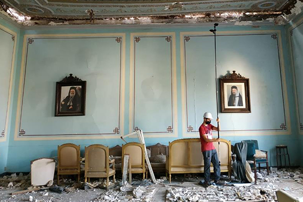
Joe Kallas, a doctoral candidate in the Penn State Department of Architectural Engineering, organized an emergency mission to document the structural damage of historic building in Beirut, Lebanon, following the Aug. 4, 2020, explosion. Credit: Provided by Joe Kallas/Penn State. All Rights Reserved.
Beyond buildings: Architectural engineers work to preserve heritage
Rapid-response 3D modeling helped guide structural preservation efforts after 2020 Beirut explosion
July 7, 2023
By Ashley WennersHerron
UNIVERSITY PARK, Pa. — Three years ago, one of the largest non-nuclear explosions in history blasted through Lebanon’s capital, Beirut. The accidental detonation of improperly stored ammonium nitrate killed 218 people, injured thousands and caused billions of dollars in property damage across what is considered one of the oldest cities in the world. Joe Kallas, a doctoral candidate in the Penn State Department of Architectural Engineering from Beirut, was in the city that day and witnessed the devastation to the historic neighborhoods firsthand.
“I felt a strong sense of duty and responsibility to contribute to the recovery efforts using my expertise as an architect, cultural heritage specialist and expert in heritage digitization,” said Kallas, who volunteered in the aftermath to lead an emergency documentation mission to collect actionable intel where none existed to help accelerate restoration efforts. “Preserving and appreciating buildings as part of our heritage ensures the continuation of our collective history, enriches our understanding of the past and enhances the cultural fabric of communities.”
Since then, Kallas partnered with Rebecca Napolitano, assistant professor of architectural engineering at Penn State, to present the Beirut blast as a case study demonstrating how image-based 3D modeling can serve as a prioritization tool to inform disaster recovery decision-making. They published their approach in the July-Aug. edition of the Journal of Cultural Heritage.
“In this paper, we shared the comprehensive workflow diagram that showcases the various steps and processes that were employed in this emergency mission,” Kallas said. “This can be used in future post-disaster planning to facilitate the remote assessment of damaged historical buildings and accelerate the implementation of emergency interventions.”
During Kallas’ emergency documentation, starting just two days after the explosion, he led 12 team members in documenting 240 moderately damaged buildings. Kallas documented 40 highly at-risk buildings himself. They used an imaging technique called photogrammetry, in which the relationships between multiple images of an object or a scene taken from different perspectives are analyzed and then converted to 3D models that accurately capture the geometry of the object. They also produced textured models of the buildings, capturing the degree of structural deformation throughout each one.
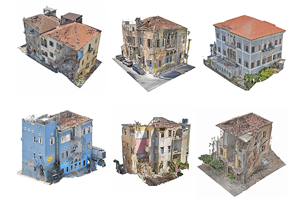
The researchers documented damaged buildings in Beirut and used the images to generate 3D models detailing their structural deformations. Credit: Provided by Joe Kallas/Penn State. All Rights Reserved.
Kallas and the team provided the documentation to the engineers and other experts under Lebanon’s Directorate of General Antiquities, a unit of the country’s Ministry of Culture. The directorate then used the information to decide which buildings were in imminent danger of further damage and prioritize which were first reinforced and protected against the elements.
The models also helped inform more detailed structural analysis, Kallas said, providing critical information to engineers tasked with correcting specific deformations. He added that the researchers helped finalize the files with repair details — information required for any requests to fund the restoration.
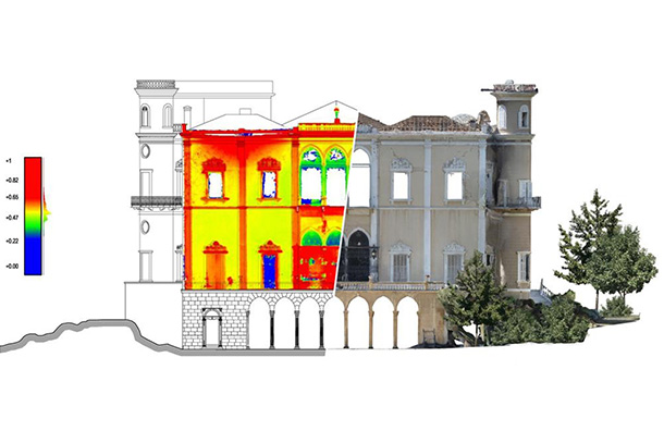
In this generated 3D model, scalar field classification — the physical points in space across an object — showcases the structural deformations on one of the buildings damaged during the blast. Credit: Provided by Joe Kallas/Penn State. All Rights Reserved.
“During this process, it became clear that this case study could serve as an exceptional example of how technology can effectively enhance disaster response and recovery,” Kallas said. “It demonstrates the power of leveraging digital tools and techniques to rapidly assess damage, inform decision making and facilitate necessary emergency interventions.”
The resulting workflow that Kallas and Napolitano derived from this case study comprises eight steps: mission planning; data collection; image selection; image processing; 3D model generation; model refinement; damage assessment; and visualization and analysis. Critically, Kallas noted, this workflow relies on more commonly available equipment, such as digital cameras and commercial drones, and more efficient software than other techniques.
In addition to saving time and money, Kallas said, the 3D models provide a clear and intuitive representation of the building’s condition, making it easier for all stakeholders — including cultural heritage experts, engineers and other decision makers — to collaborate and prioritize interventions. However, he cautioned, it’s only a first step.
“The digital documentation mission conducted in Beirut serves as a powerful example of how image-based 3D modeling can be harnessed to ensure the survival and restoration of existing historic structures,” Kallas said. “This effort highlights the urgent need for standardization in the digitization of cultural heritage, paving the way for its integration into structural health monitoring and the development of comprehensive heritage risk management plans.”
Now, Kallas said he is working with Napolitano to integrate artificial intelligence and machine learning into the assessment process for damaged historical buildings in post-disaster areas with the goal of expediting recovery efforts.